
Key takeaways
Best hiking in Yosemite National Park spans the granite-walled Valley, the lofty views off Glacier Point, and the alpine high country along Tioga Road. This guide organizes six top trails by region, with real distances, elevation, and difficulty, plus a packing list, so you can plan a route close to where you’re staying and hike it prepared.
Our top picks


![Yosemite Day Hikes and National Park Map [Map Pack Bundle] (National Geographic Trails Illustrated Map)](https://m.media-amazon.com/images/I/81JiL2h8mCL._AC_UY218_.jpg)

 Yosemite National Park Map
- Publisher : National Geographic Maps
- Edition : 2025th
- Language : English

As an Amazon Associate we earn from qualifying purchases at no extra cost to you.
As an Amazon Associate we earn from qualifying purchases.
🛒 Best Price Today on Amazon
Prime members get fast, free shipping on everything above, plus member-only deals. New members get a 30-day free trial — cancel anytime.
Yosemite Valley Trails
The Valley is where most visitors stay and where the park’s most famous waterfalls live. These three routes start near the valley floor and range from a family stroll to a lung-busting climb, covering the best hiking in Yosemite National Park’s heart. All three trailheads sit within a short drive or shuttle ride of the main lodges.
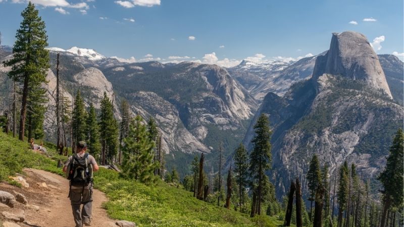
Mist Trail to Vernal and Nevada Falls
About 6 to 7 miles round trip from Happy Isles with roughly 1,900 feet of gain, this moderate hike is the Valley’s signature route. You climb a granite staircase beside the falls, drenched in spring spray with rainbows in the gorge. It’s a strenuous but achievable climb that turns many first-timers into repeat visitors.
Grippy shoes are a must on the wet steps, which close in winter for ice. Descend the John Muir Trail to spare your knees and enjoy a quieter, scenic loop back to the trailhead. In spring, expect to get soaked by the spray, so pack a shell and protect your phone.
Upper Yosemite Falls Trail
This strenuous 7.2-mile round trip gains about 2,600 feet to the top of North America’s tallest waterfall. Columbia Rock partway up offers commanding valley views, and the falls thunder loudest in spring snowmelt.
The relentless switchbacks bake in afternoon sun, so start early. Near the top, stay well back from the slick, exposed edges where the drop is sheer and the granite stays wet. Columbia Rock, about a mile up, is a worthy turnaround if the full climb feels too steep.
Mirror Lake
An easy 2-to-4.4-mile round trip with only 100 to 300 feet of gain, Mirror Lake is the Valley’s best family walk. The seasonal lake reflects Half Dome in spring before receding to a meadow by late summer.
The flat, partly paved path suits kids and casual walkers, and the Valley Loop Trail extends it if you want more distance. Spring and early summer bring the fullest water and the classic reflection. Benches and shade along the way make it an easy outing with young children.
Glacier Point and High Country Trails
Above the Valley, Glacier Point Road and Tioga Road open a higher, cooler world of granite domes and alpine lakes. These three showcase the best hiking in Yosemite National Park’s high country, accessible mainly in the warm season. Together with the Valley routes, they cover the park’s distinct regions.
Sentinel Dome
A short 2-mile round trip off Glacier Point Road, Sentinel Dome gains just a few hundred feet to a 360-degree summit with a stunning Half Dome view. It’s easy to moderate and one of the park’s best effort-to-reward ratios.
The road opens roughly late spring through fall, so plan a warm-season trip. It’s a superb sunset spot, but bring a headlamp if you stay for the light. Combine it with nearby Taft Point for two big viewpoints in one short outing.
Cathedral Lakes
In Tuolumne Meadows, this moderate 7-mile round trip gains about 1,000 feet to alpine lakes beneath the spire of Cathedral Peak. It’s a gentler introduction to Yosemite’s stunning backcountry.
The high trailhead is only reachable when Tioga Road is open, typically late spring through fall. Summer afternoons bring thunderstorms, so start early and keep an eye on the sky. The clear alpine water and granite backdrop make it one of the park’s most photogenic spots.
Four Mile Trail to Glacier Point
A strenuous route of about 9.6 miles round trip with roughly 3,200 feet of gain, the Four Mile Trail climbs from the valley floor to the sweeping overlook at Glacier Point. The views of Half Dome and the Valley grow more dramatic with every switchback.
Many hikers ride the shuttle one way and hike the other to cut the effort. The exposed lower switchbacks get hot, so carry ample water and start in the cool morning. Riding the Glacier Point shuttle up and hiking down turns it into a knee-friendly one-way descent.
What to Pack for Yosemite
Since the best hiking in Yosemite National Park ranges from warm valley floors to cool granite summits and slick waterfall stairs, dependable footwear and smart layering are essential. Here are the items to bring, with solid choices on Amazon.
| Gear | Why You Need It |
|---|---|
| Grippy hiking shoes | Wet granite and steep stairs demand traction |
| Trekking poles | Knee relief on big Valley-to-rim descents |
| Hiking daypack | Carry water, layers, and food all day |
| Insulated water bottle | Hydration on hot, exposed climbs |
| Rain shell | Waterfall spray and high-country storms |
Footwear and Poles
Slick granite is the constant hazard, so a sticky-soled shoe like the Salomon X Ultra or Merrell Moab is your most important buy. Trekking poles such as the Cascade Mountain Tech carbon pair steady you on wet steps and ease the pounding on long descents like the Four Mile Trail. Break in new shoes before your trip to avoid blisters on the park’s long, rocky miles.
Pack and Hydration
A comfortable daypack like the Osprey Talon 22 carries everything for a long day, and an insulated bottle such as a Hydro Flask keeps water cold on shadeless climbs. On big routes, a hydration reservoir lets you drink without stopping. Top off water at the lodges or visitor centers before you head out for the day.
Weather and Sun Protection
Pack a light rain shell for the Mist Trail’s spray and sudden high-country thunderstorms, plus a headlamp like the Black Diamond Spot for early or late hours. A wide-brim hat, sunglasses, and sunscreen guard against the intense high-elevation sun. A light insulating layer packs small and saves the day when summit winds pick up.
Frequently Asked Questions
A few questions come up again and again when planning the best hiking in Yosemite National Park. Here are quick, practical answers.
Which region has the best hikes?
The Valley holds the famous waterfall hikes, Glacier Point offers big views for less effort, and the Tuolumne high country delivers alpine lakes and quieter trails. The best region depends on where you’re staying and the season. Sampling all three gives you the fullest picture of the best hiking in Yosemite National Park.
When do the high-country roads open?
Tioga Road and Glacier Point Road typically open by late spring and close with the first heavy snow in fall, so high-country trails are seasonal. Check current road status before planning a Tuolumne or Glacier Point hike. These seasonal routes are a highlight of the best hiking in Yosemite National Park.
Do I need a reservation to enter?
Yosemite often requires a timed-entry reservation during peak season, and Half Dome needs a separate lottery permit. Requirements change year to year, so confirm the current rules on the park’s official site before your trip. Booking lodging and entry early is the surest way to secure a peak-season visit.
Are the trails dog-friendly?
Most Yosemite trails don’t allow dogs, though pets are permitted on some paved paths and in developed areas. If you’re hiking with a dog, check the park’s pet rules and plan around the limited dog-friendly routes. Most hikers leave dogs at home and enjoy the full range of trails instead.
See More:
- Best daypacks for hiking
- Best hiking sneakers men
- Best backpack for hike
- Best backpack for carry on
- Best travel backpack for men
Final Thoughts
The best hiking in Yosemite National Park depends on your region and season, from Valley waterfalls to Glacier Point vistas and Tuolumne’s alpine lakes. Plan around where you’re staying and the road openings, pack grippy shoes, poles, water, and a rain shell, and confirm permits — and the park’s scenery will more than repay the effort.







Write Your Review
No reviews yet. Be the first to share your experience!